


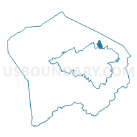
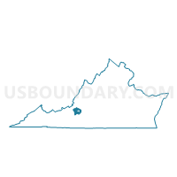
Plantation Voting District, Roanoke County, Virginia
About
Outline

Summary
| Unique Area Identifier | 682429 |
| Name | Plantation Voting District |
| County | Roanoke County |
| State | Virginia |
| Area (square miles) | 0.91 |
| Land Area (square miles) | 0.91 |
| Water Area (square miles) | 0.00 |
| % of Land Area | 100.00 |
| % of Water Area | 0.00 |
| Latitude of the Internal Point | 37.33077810 |
| Longtitude of the Internal Point | -79.94453660 |
Maps

Graphs
Select a template below for downloading or customizing gragh for Plantation Voting District, Roanoke County, Virginia


Neighbors
Neighoring Voting District (by Name) Neighboring Voting District on the Map
- Burlington Voting District, Roanoke County, VA
- Hollins Voting District, Roanoke County, VA
- Monterey Voting District, Roanoke city, VA
- Mountain View Voting District, Roanoke County, VA
- Williamson Road No. 6 Voting District, Roanoke city, VA
Top 10 Neighboring County Subdivision (by Population) Neighboring County Subdivision on the Map
Top 10 Neighboring Place (by Population) Neighboring Place on the Map
Top 10 Neighboring Unified School District (by Population) Neighboring Unified School District on the Map
Top 10 Neighboring State Legislative District Lower Chamber (by Population) Neighboring State Legislative District Lower Chamber on the Map
Top 10 Neighboring State Legislative District Upper Chamber (by Population) Neighboring State Legislative District Upper Chamber on the Map
Top 10 Neighboring 111th Congressional District (by Population) Neighboring 111th Congressional District on the Map
Top 10 Neighboring Census Tract (by Population) Neighboring Census Tract on the Map
- Census Tract 302.04, Roanoke County, VA (6,671)
- Census Tract 4, Roanoke city, VA (4,761)
- Census Tract 302.03, Roanoke County, VA (3,975)